See & Do

Mukinbudin is a vibrant, rural town, located 295km North East of Perth in the heart of the Eastern Wheatbelt. With cool winters and hot summers, whatever time of year you visit there is so much to see and do. 

Mukinbudin is undoubtedly a place for those who have an interest in the outdoors. There are no better places to experience this than at Beringbooding Rock and Weira Reserve. Anything from four-wheel driving, barbequing, camping, bushwalking and spectacular views can be experienced amongst these attractions. Anyone with even a passing interest in the history of the area should visit the Wattoning Historical Site, Goodchild’s Gateway and the unique Bulk Grain Storage Silo or the 1950’s Men’s Shed.

To help you get the most out of your time here, we have put together a list of our favourite things to do in the area.

Karloning Rock

Beringbooding Rock has the largest rock water catchment tank in Australia, built-in 1937 and holding two and a quarter million gallons. “Sustenance Labour” was used to build the tank at a cost of 10,000 pounds. Beringbooding also has an amazing balance boulder, a huge gnamma hole, and some of the Kalamaia tribes’ paintings of hands in a cave at the rear of the rock. Two early pioneer wells are also located nearby.

Spring finds the pink ti-tree, heart-shaped leaf eucalyptus melaleuca, acacia, grevillea, hakea, calothamnus, eromophilia, cassia, quandongs, sandalwood, and the native orchids flowering. Later into October and November the Kunzia Pulchella and one-sided bottlebrush flower profusely and many birds inhabit the area. Well worth a visit by anybody in the area.

Beringbooding Rock has great picnic and free camping facilities with easy caravan access, a flushing house hold toilet, picnic tables, firepit BBQs, interpretative signage, and a marked walk trail.

Cleomine was farmed by George Lansdell, a prominent Perth bookmaker and racehorse owner. The property was called ‘Cleomine’ after Lansdell’s greatest horse, the 1920’s equal of Black Caviar. George Lansdell spelled his horses on this farm and many trainers, strappers and jockeys also came to Cleomine to train, work and rest.

The Cleomine Horse marks the spot where George built an impressive mudbrick five-roomed homestead, also adding a general store, butcher shop and blacksmith shop to serve the local settlers. He ran sheep, cattle and turkeys on his farm which supplied the butcher shop. The buildings were constructed from bricks manufactured and fired on site.

Elachbutting Rock is a massive granite outcrop based in the Shire of Westonia. It is a very popular camping spot for 4×4 wheel clubs and for locals, as well as a popular site for weddings. The name Elachbutting is thought to mean ‘big things standing’ which is quite feasible as Elachbutting is a large granite rock and a prominent landmark standing out from the surrounding countryside with excellent views from the top . It has a spectacular colorful rainbow wave similar to Hyden’s Wave Rock with the added beauty of ‘Monty’s Pass’, a 30m tunnel caused by a rock slide. An echoing cave, “Kings Cave”, similar to an amphitheatre is close by. The 6km track around the rock with its dense trees and shrubs hide many interesting species of flora. The east side is renowned for its masses of Donkey Orchids at the base to the rock in a wet year.

An excellent place to camp with barbeques, picnic tables and a toilet, Elachbutting has a reputation for being bigger, better and more pristine than any Wheatbelt granite rock formation that you may have seen before. The rock is around 100km north of Westonia and is easily accessed via well maintained gravel roads. Visitors are encouraged to take all they need for a day trip and then take all they took home with them again. Dogs are not allowed.

elachbutting rock

Located nine kilometres north of Mukinbudin on the Mukinbudin/Wialki Road.

This gateway was constructed in 1947 by Stan Goodchild, the then property owner, in memory of his son Harold who was killed in action in December 1944 while serving with the RAAF. The two 32 volt lights were orginially powered by wires from the distant homestead.The gateway was restored in 2003 with the co-operation of the present owners AL & ME Shadbolt and family and the Shire of Mukinbudin.

Situated 8kms east of the townsite, this site honours and tells the story of Colonel Harold Pope, John Mulqueeny and the returning soldiers who contributed greatly to the development of farming land in the Lake Brown area which was the first large-scale Soldier Settlement Scheme in Western Australia. Stay tuned as we have an exciting project in the works at Pope’s Hill.

A field of flowers growing under the glow of the sunlight and in front of Popes Hill sign

A local art pop-up art gallery in Mukinbudin opens from the 1st of August – 31st of October, located in the Mukinbudin Memorial Hall on Shadbolt Street which is open weekdays 9 am-3 pm and on Weekends 10 am-2 pm. It showcases local and visiting artists in iconic spaces within our town. From watercolor, canvas, textile, clay, wood and so much more. There are so many mediums to discover in our ever-changing exhibition space over the next few months.

This time of year is a wonderful time to be in the Wheatbelt as we have lots of visitors passing through our community. An occasional pop-up gallery and window display in the old Westpac Bank. For more information visit their Facebook Page or Instagram Page.

A 4.6 kilometre walk around the townsite of Mukinbudin.  The trail starts at the botanical garden where there is a rare and endangered walk showcasing local flora which then extends out into the recreational trail.

This trail has markers at strategic points. The markers are a small round sign with a figure walking.

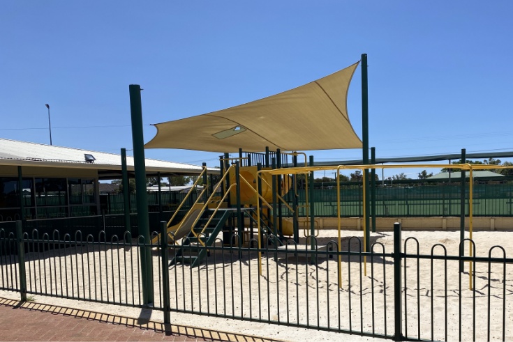
Around the trail various equipment has been installed.  Four lifestyle stations have been installed at intervals for your use.  Seating and two water fountains are available along the trail.

You are more than welcome to walk dogs along the trail providing they are on a leash.  It is asked that owners remove any of their pets excrement.  At both water fountains dog bowls are provided for pets to drink from.

Download a copy of the map here.

Mukinbudin boasts Recreational Facilities second to none in the Wheatbelt Area.

Facilities include:

  • Olympic Size Swimming Pool (50m)
  • Grassed town oval similar to the WACA dependant on water!!
  • Indoor & Outdoor Basketball Courts
  • Indoor & Outdoor Netball Courts
  • Cricket Facilities
  • 4 All Season Artificial Turf Tennis Courts
  • Hockey Field
  • Squash Court
  • Synthetic Bowling Greens
  • Dirt Kart Track
  • Pistol Range
  • Pony Club Facilities
  • 18 Hole Golf Course with modern clubhouse facilities
  • Pump Track
playground and fence at the mukinbudin recreation grounds
image taken from the sky of the mukinbudin football oval and recreation grounds
pump track at the mukinbudin recreation grounds

Built in 1949 by the late Lloyd George (Jack) Jones. As the silo was progressively filled with grain, Mr Jones constructed the curved corrugated iron walls. He dug huge holes and trenches for the enormous timber main frame. Fashioned from the local bush with only an axe, he hoisted the poles up by using two 40KVA Chamberlain Kerosene tractors. The roof was constructed after the silo was filled. An early model tractor auger on a Fordson tractor was used to fill the silo.

The silo was originally located approximately 3 kilometres north of the Mukinbudin townsite and had fallen into disrepair due to summer storms and termites. With the aid of funding from Lotteries WA and Co-operative Bulk Handling along with much community support the Silo has being dismantled, restored and re-erected in Mukinbudin in recognition of the importance of the grain growing industry to this area and also the initiative and innovation of our pioneers.

large great unique bulk grain silo standing in mukinbudin
Signage describing the Unique Heritage Grain Silo in Mukinbudin

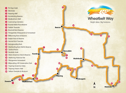
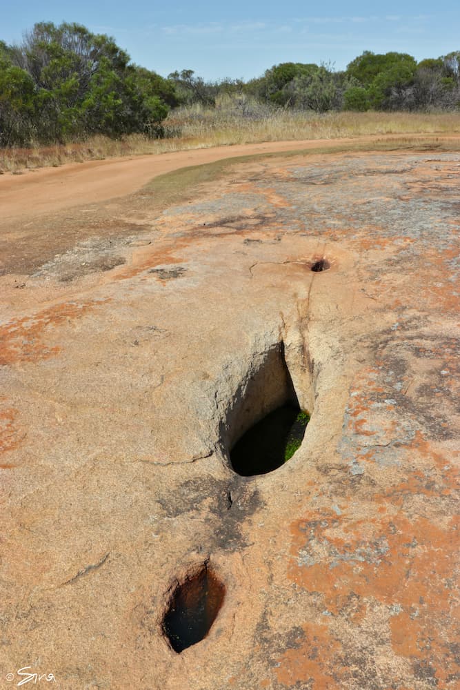
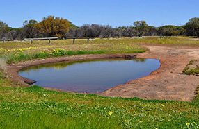
A granite outcrop with an interesting large circular gnamma hole. When flowering, the Kunzea Pulchella can be found in both the red and white varieties.

The Wattoning gnamma hole was an important water site for Aborigines. In the late 1800’s two rock lined wells and a soak were constructed by early pastoralists and precious water was carted from these by pastoralists, sandalwood cutters and prospectors. The water was lifted by buckets tied to a rope.

A homestead was constructed in 1873 by James Ward who lived here until about 1890 when it was then inhabited by the Ives Family and then later still by the Hall Family. Both families lost children who are buried in the small graveyard alongside an earlier pioneer. The homestead was then vacant after the tragic death of Mr Hall’s child. Their stories are told on the excellent interpretive signage at the gravesite.

The vacant homestead was then used as a camp by Sandalwooders, who would pull wood in the bush and bring it back to Wattoning for cutting and cleaning. Wattoning homestead was burnt down sometime after 1911. Local Legend has it that some of these men, having too much to drink, became careless and a fire started which quickly gutted the thatched house. At the homestead site there is a picnic table and signage describing life at Wattoning in the early days. There are also the remains of a soak and two wells.

Located 13 kilometres east of Mukinbudin is the Weira Reserve. It boasts a picturesque limestone breakaway with a gnamma hole. There are barbecue, picnic and camping facilities including a toilet. Native flora and fauna abounds. Native orchids may be found on the bush trail and keep an eye out for the Red Capped Robin.

The large gnamma hole like many gnamma holes in the region was an important water source for the Aboriginals, pastoralists who shepherded their sheep throughout the region, miners on route to the goldfields, and sandalwood cutters.

Weira reserve

The best times to view wildflowers along the Wheatbelt Way are from mid-July through to mid-September with different species putting on their displays over the season (depending on rainfall received). Some orchid and wattle species flower as early as April and May. In normal seasons opening rains set the district up for a brilliant display of wildflowers including masses of white, pink and yellow everlastings, up to 20 varieties of orchids and many bigger trees and shrubs such as wattles, melaleuca, hakea, grevillea, and climbing clematis vines. Acacias are a feature around the granite rocks. Calothamnus quadrifidus provides a great display of red one-sided flowers and as does Leptospermum erubescens with its show of pink and white. If you keep your eyes open you may see the upside down pea bush with red flowers.

Yanneymooning Hill is a 532ha Nature Reserve located in the Shire of Westonia on the corner of Elachbutting and Echo Valley Roads 75kms
north of Westonia, comprising of granite rock formations and bushland.

The rock offers spectacular views of a variety of birdlife and flowers, the eucalyptus garden species “Silver Princess” in its natural state can be found on the rock cascading into the valley below. Bottlebrush flowers in October/November. Cowslip and Patricia’s Spinder Orchid along many others can be found at the base of the rock in Spring. Yanneymooning is on the road to Elachbutting and is ideally situated to visit on a trip to Elachbutting Rock.

No camping and pets are permitted.

wheatbelt way

Wheatbelt Way

The Wheatbelt Way self-drive trail will lead visitors on an adventurous interpreted journey through the communities of Beacon, Bencubbin, Dowerin, Koorda, Mukinbudin, Nungarin, Trayning, Westonia and Wyalkatchem.

It highlights 24 interpreted sites of the many natural attractions and history/heritage sites while offering you opportunities to stay and experience the unique Wheatbelt communities and landscapes.

Download the Wheatbelt Way Self Drive Trail Guide app with detailed information on each of the nine towns and sections on each of the 24 interpreted sites included in the tour to guide you on your journey through the North Eastern Wheatbelt.

Please visit the Wheatbelt Way website for more information:

http://www.wheatbeltway.com.au/

Whats in town?

View our current list of businesses and services operating within Mukinbudin.